If interested, one could walk to the Farm of Sabaragamuwa University that is situated in walking distance and see the farm animals. The site where the first ever wind-powered furnace used for making “Balangoda Steel” is situated in walking distance from Windy Hills Bungalow. Other than that, few attractions like Bambarakanda Falls, Sri Lanka’s tallest (790 ft) and worlds 299 th tallest, Surathali Ella, Samana Wewa, Belihuloya, Haldummulla ancient Portuguese Fort, ancient Soragune Devalaya, oldest and first ancient human dwelling to be found in the central hills in Sri Lanka, famous Adisham Bangalow and Udawalawa National Park Rajawaka entrance can also be reached within reasonable timeframe. For more adventures tourist, mountain hiking and biking options could be arranged on request.
Surrounding the Site

Bird Watching
Thera are lot of bird sittings in and around where the Bungalows is situated. Research done in the area indicate that Belihuloya support a particularly rich avifaunal diversity. Of Sri Lanka’s 240 breeding resident bird species, 24% were recorded in the area. Among them, endemic species percentage was 44%. About 15 species of endemic birds could be seeing in the area, including five nationally threatened species.
An ancient wind-powered iron smelting technology in Sri Lanka
[ 1.5 Km | 10 Min | Open in Maps ]
An ancient wind-powered iron smelting technology in Sri Lanka. BEFORE the development of the blast furnace, iron smelting was achieved by ore reduction at temperatures below the melting point of the metal, forming an agglomerated 'bloom' of low-carbon iron and slag.
This technology sustained a major industry in this area during the first millennium AD, and may have contributed to South Asia's early pre-eminence in steel production.

Worlds End Trail
[10 Km | 1-2 Hrs | Open in Maps]
The Horton Plains plateau comes to a sudden end at World’s End, a stunning escarpment that plunges 880m. The walk here is 4km, but the trail then loops back to Baker’s Falls (2km) and continues back to the entrance (another 3.5km). The 9.5km round trip takes a leisurely three hours. Unless you get there early, the view from World’s End is often obscured by mist, particularly during the rainy season from April to September.
Soragune Devalaya
[24.1 Km | 44 Min | Open in Maps ]
Soragune Devalaya dedicated to Lord Katharagama has a long history running back to several centuries and the details of this place are included in the ancient documents owned by the Devalaya such as thudapatha, medagama sannasa and lekam mitiya. This sacred devalaya was built by a provincial King Yapa in this year 1582 A.D.in Oder to fulfill a vow made by him, in connection with a battle that he had won. The details of this event are found in Medagama Royal Grant and other document available with the devalaya’ this devalaya can be reached by travelling 5 km along Kirawanagama road branching off at Halatuthenna town on Colombo Badulla highway.


Diyaluma Falls
[43.6 Km | 1 Hr 25 Min | Open in Maps ]
Diyaluma Falls is 220 m (720 ft) high and the second highest waterfall in Sri Lanka and 361st highest waterfall in the world. It is situated 6 km (3.7 mi) away from Koslanda in Badulla District on Colombo- Badulla highway. The Falls are formed by Punagala Oya, a tributary of Kuda Oya which in turn, is a tributary of Kirindi Oya. In Sinhalese, Diyaluma or Diya Haluma means "rapid flow of water" or may be translated as "liquid light". According to Sri Lankan historian, Dr. R. L. Brohier, Diyaluma is the setting of the folklore about a tragedy involving a young chieftain who had been banished to the highlands and the attempt by his betrothed to join. As all the passes were guarded the young man let down a rope of twisted creepers over the escarpment, as she was hauled up she was dashed against the rocks and died. The Gods, moved to pity by the harrowing spectacle, caused a stream of water to gush from the mountain and veil all evidence of the tragedy in a watery light, hence the term Diyaluma.
Bambarakande Falls
[19 Km | 45 Min | Open in Maps ]
Bambarakanda Falls (also known as Bambarakele Falls) is the tallest waterfall in Sri Lanka. With a height of 240.792 m (790 ft), it ranks as the 299th highest waterfall in the world. Situated in Kalupahana in the Badulla District , this waterfall is 5 km away from the A4 Highway. The waterfall was formed by Kuda Oya , which is a branch of the Walawe River. The Bambarakanda Falls can be found in a forest of pine trees.


Portuguese Fort Haldummulla
[19 Km | 30 Min | Open in Maps ]
Haldummulla Fort, also known as Katugodalla Fort, was built by the Portuguese in Haldummulla, Badulla. The 17th century fort was completely destroyed except the foundations, which can still be seen today in the forestry hill area. It served as a frontier post and staging post for Colombo.
Oldest human dwelling in Sri Lanka excavated from Badulla
Professor Raj Somadeva of the Post Graduate Institute of
Archaeology at Kelaniya University says that excavations in Haldummulla in
Badulla district have led to the discovery of the oldest human dwelling
identified on the island so far.
The archaeological site in Koswatta, Haldummulla, is situated 850 meters above sea level
and it is the highest ground that remains of ancient human dwellings have been reported.
The archaeologists have recovered the foundations of four houses and believe more remain
under soil.


Koswatta, Haldummulla Ancient Human Dwelling & Burial ground
[21 Km | 36 Min | Open in Maps ]
In 2010, a group of researchers found evidence of a Prehistoric burial ground in Haldummulla. In 2011 archaeologists found evidence of an ancient settlement, it’s the oldest and first ancient human dwelling to be found in the central hills in Sri Lanka. Archaeologists have unearthed a human dwelling in Haldummulla, Sri Lanka, which they believe is the oldest of its kind identified on the island so far. Prof. Raj Somadeva of the post graduate institute of Archaeology in the Kelaniya University said that it was discovered in an archaeological excavation carried out near Koswatta village in Haldummulla.
Lipton's Seat
[42 Km | 1 Hr 30 Min + 2 Hr climb | ">Open in Maps ]
The point of Lipton’s Seat is reached by climbing for around 7km surrounded by peaceful green tea plantations and an occasional colorful tea plucker. There are two routes available; one from the Nayabedda estate in Bandarawela , and the second through the Dambatenna estate in Haputale. Both routes have entrances marked with sign boards and narrow paved roads. Some parts of the road even have some of the original stone constructions from the British era of Ceylon, and hence are worth seeing from a historical point of view. The climb takes about two and a half hours on average, after a visitor reaches the hill top. From Lipton’s Seat the Uva, Sabaragamuwa, Central and Eastern provinces spread out from before the feet of the viewer in a display rivaling that of the famed World’s End observation point. Visible from the hill top are 7 provinces along with sights such as Handapanagala Lake, Chandrika Lake, Udawalawe Lake, Wedihitikanda Mountains, and even the Hambanthota harbor from the Southern coast.

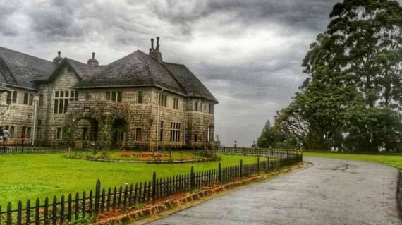
Adhisham Bungalow
[32 Km | 50 Min | Open in Maps ]
Adisham Hall, or Adisham Bungalow is a country house near Haputale , in the Badulla District , Sri Lanka. At present, it houses the Adisham monastery of Saint Benedict. It has a relic (a chip of a bone) of St. Sylvester at the chapel. The house was built in 1931 by an English aristocrat and planter Sir Thomas Villiers, former Chairman of George Steuart Co, a trading and estate agency based in Colombo. Sir Thomas was a grandson of Lord John Russell and descendant of the Dukes of Bedford. Named after Adisham , it was designed by R. Booth and F. Webster in Tudor and Jacobean style, on 10 acres (40,000 m 2 ) of land. Adisham Hall played host to many prominent personalities of the colony until the retirement of Sir Thomas, after which it was sold to Sedawatte Mills in 1949. In 1961 it was purchased by the Roman Catholic Church and was subsequently converted to a monastery. The house is well preserved along with its period fittings and furniture, and is open to visitors.
Duwili Ella in Kaltota Lankagama
[40 Km | 1 Hr 20 Min | Open in Maps ]
Doovili Ella Falls or Duvili Ella or Walawe Ganga East Falls (Sinhala: දූවිලි ඇල්ල) is a waterfall in Ratnapura District , Sri Lanka. It is located in Thanjantenna village, which is about 4 km (2.5 mi) away from Balangoda. The height of the waterfalls is about 40 m (130 ft). The name 'Duwili' is derived from the Sinhalese for dust, which describes the spray emanating from the waterfall.

Udawalawe National park Handagiriya entrance
[ 45 Km | 1 Hr 30 Min | Open in Maps ]
Udawalawe National Park lies on the boundary of Sabaragamuwa and Uva Provinces, in Sri Lanka. The national park was created to provide a sanctuary for wild animals displaced by the construction of the Udawalawe Reservoir on the Walawe River, as well as to protect the catchment of the reservoir. The reserve covers 30,821 hectares (119.00 sq mi) of land area and was established on 30 June 1972. Before the designation of the national park, the area was used for shifting cultivation (chena farming). The farmers were gradually removed once the national park was declared. The park is 165 kilometres (103 mi) from Colombo. Udawalawe is an important habitat for water birds and Sri Lankan elephants. It is a popular tourist destination and the third most visited park in the country